- Region
- Vega baja
- Marina Alta
- Marina Baixa
- Alicante
- Baix Vinalopo
- Alto & Mitja Vinalopo
-
ALL TOWNS
- ALICANTE TOWNS
- Albatera
- Alfaz Del Pi
- Alicante City
- Alcoy
- Almoradi
- Benitatxell
- Bigastro
- Benferri
- Benidorm
- Calosa de Segura
- Calpe
- Catral
- Costa Blanca
- Cox
- Daya Vieja
- Denia
- Elche
- Elda
- Granja de Rocamora
- Guardamar del Segura
- Jacarilla
- Los Montesinos
- Orihuela
- Pedreguer
- Pilar de Horadada
- Playa Flamenca
- Quesada
- Rafal
- Redovan
- Rojales
- San Isidro
- Torrevieja
- Comunidad Valenciana
The PR-MU 1 walking route on Cabezo de la Fuente in the regional park of Calblanque
A 7.8-kilometre walk with spectacular views of the Mediterranean coastline in Calblanque
Sendero Circular al Cabezo de la Fuente PR-1
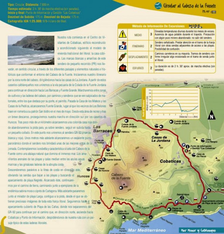
This circular route around the 336-metre mountain of Cabezo de la Fuente in the regional park of Calblanque, on the Mediterranean coast in the east of the municipality of Cartagena, usually takes around two and a half hours to complete at a brisk walk without stops, and offers some spectacular views as well as a variety of landscapes and points of natural and historical interest.
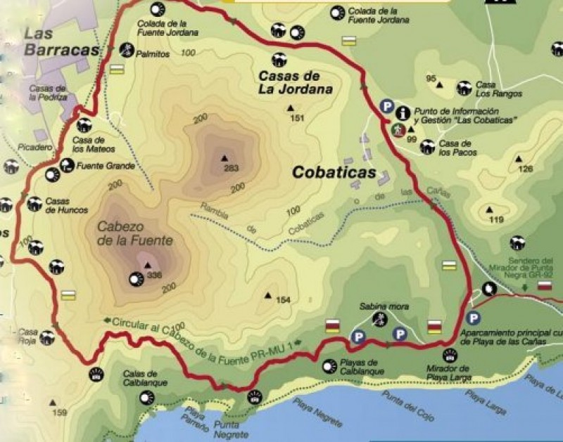
The walk includes climbs and descents of 175 metres, and starts and finishes at the information point of Las Cobaticas, which is housed in a building which has been remodelled to reflect the kind of homes which were traditional in this part of the Costa Cálida in the past.
The yellow and white markings of the PR route first take us to the northern side of the Cabezo de la Fuente and the small village of La Jordana, from where the path joins the old drovers’ road of Colada de la Fuente and continues towards Las Barracas and Fuente Grande. Here, between crop fields and the lower slopes of the mountain, the paths are surrounded by plants including dwarf palms, and walkers pass the Casa de los Mateos and the Casas de la Pedriza before reaching Fuente Grande, which is the destination of the Romería in which the figure of San Isidro is brought by the residents of Los Belones every May.
Fuente Grande is a good spot for a short rest before continuing to the homesteads of Huncos, and then a kilometre further on to a red house: here we change direction to climb a small hill and join the major GR-92 path (marked in red and white). Just beyond this point there are impressive panoramic views, among the best to be seen along the route, including the characteristic silhouette of Cabezo de la Fuente, a natural vantage point over the Mediterranean. At the same time, the yellowish sand contrasts beautifully with the blue sea and the greyish hue of the rocky coastline.
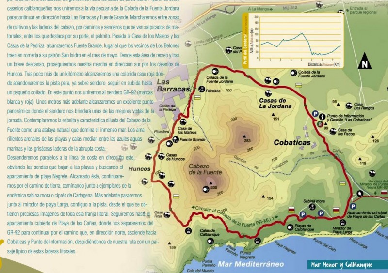
Descending eastwards, parallel to the coast, and ignoring the paths which shoot off to the beach, the route heads for the car park of Playa Negrete, where it then continues on a an unsurfaced path among the native junipers and tetraclinis trees. There is then a viewing point looking out over Playa Larga before walkers reach the car parking area of Playa de las Cañas: here the route leaves the GR-92 and heads north, climbing back up to the information point of Cobaticas.
This walk is located inside the regional park of Calblanque, and is easily accessed by road from the RM-12 road to La Manga del Mar Menor.
Cobaticas Information Centre, Cartagena: Las Cobaticas is in the Calblanque regional park within the municipality of Cartagena, and includes wild beaches, dunes and coastal scrubland. Click for Las Cobaticas Information Centre.
Recommendations and rules:
1. The Nature Trails Network of the Region of Murcia passes through areas of natural value which must be preserved for future generations: respect for the environment helps everyone to enjoy it.
2. It is highly recommended that walkers be equipped with appropriate shoes and clothes according to the season of the year, and check the weather forecast before departure.
3. High temperatures and strong sunshine are very frequent during the summer in the Region of Murcia, so carry drinking water and wear a cap, sunscreen and sunglasses at this time of year.
4. The information and signs along the trail do not exempt you from any responsibility related to orientation problems encountered in the natural areas; it is highly recommended that walkers carry a map of the area, as well as a compass and/or GPS unit.
5. The upkeep of signs and facilities contributes to the security and joy of trail users. In case of deterioration, loss or any other enquiry please contact the Forest Guards, the Natural Protected Areas staff or the Dirección General del Medio Natural.
6. Please evaluate the information about duration and difficulty of the trail in order to adapt it to your physical capability and experience. Difficulty levels (M.I.D.E. System) have been set for the very best seasons, and the risk of using the trails is low but they can never be entirely risk-free.
7. The duration of each route itinerary is expressed as steady walking, without including rest time and stops. Include extra time for the hike if stops are planned along the way.
8. Walkers should keep the paths and environment clean by keeping with them all litter generated during the walk and placing it in the nearest bins.
9. The lighting of fires is not allowed under any circumstances, except in the seasons and sites equipped for this purpose. Please remember forest fires are one of the worst enemies of our Natural Protected Areas.
10. Please do not collect plants or disturb wild fauna. The use of binoculars and cameras will help you to enjoy and keep the images nature offers.
11. It is highly recommended that you remain within the limits of the marked paths at all times. Some trails also pass through private property: please respect those who live in natural areas and their way of life.
12. It is possible that part of the hiking trails may include forest roads or tracks suitable for motor vehicles. In this case, please walk along the left edge of the path; and, if you are in a group, preferably in single file.
13. In case of emergency, please call the Emergency Phone Number 112.
Click to see a full pdf in Spanish of walking routes in this area.
Join the Murcia What's On and Where to Go group on Facebook to keep up to date with all the latest events taking place near you: https://www.facebook.com/groups/MurciaWhatsOnAndWhereToGo/.


